Machine Learning Approaches for Understanding Vegetation Structure and Cloud Response Dynamics
Title: Machine Learning Approaches for Understanding Vegetation Structure and Cloud Response Dynamics
Project duration: 1st December 2025 – Present
Research Area: Climate biodiversity interactions, Earth observation, machine learning and causal inference.
Project Description
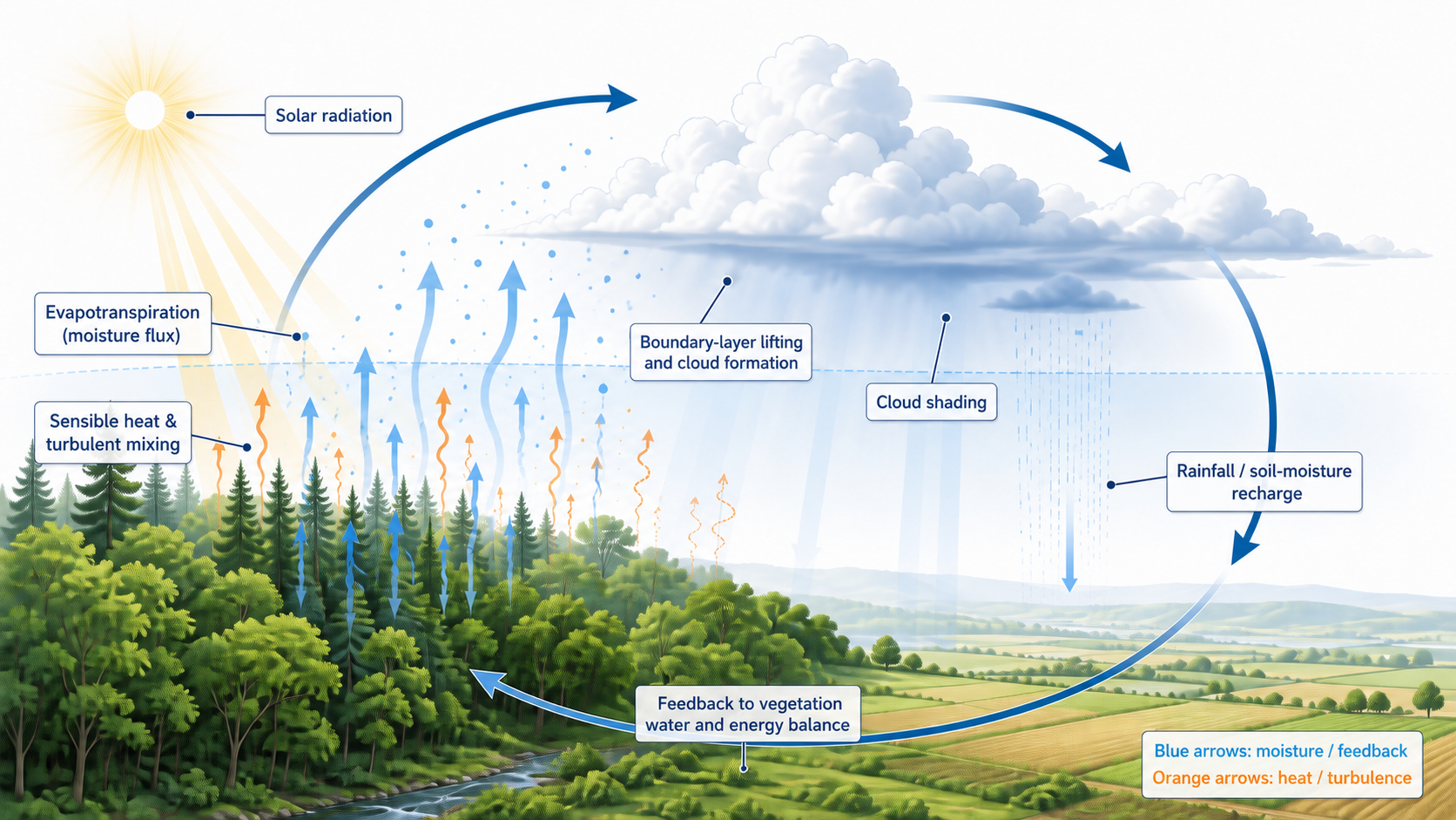
This PhD project develops artificial intelligence methods for analyzing combined climate and biodiversity data, integrating biodiversity monitoring with land-use, climate and atmospheric information. The first case study asks whether forest-cloud relationships hold consistently, or only under the right conditions. Clouds are first classified as surface-coupled or decoupled, based on whether the cloud layer is thermodynamically connected to the land beneath it; only coupled clouds can plausibly respond to local vegetation. Within each regime, the study tests whether forest-cloud relationships are consistent across cloud properties, seasons and spatial scales.
Aims
The project aims to understand how land-use practices, climate, and atmospheric conditions influence ecosystems and biodiversity. Specifically, it will:
- Conduct comprehensive data visualization and feature analysis.
- Model ecosystem and biodiversity conditions as functions of land use, climate, and atmospheric factors.
- Develop causal-inference methods to determine where and to what extent climate drives variability and changes in ecosystems and biodiversity.
Problem Statement
Vegetation and landscape diversity shape cloud formation by altering albedo, evapotranspiration, surface roughness and heat exchange. However, this relationship varies with forest type, landscape structure, season and atmospheric conditions. Satellite datasets also differ in resolution and coverage, making simple comparisons unreliable. A scalable, data-driven framework is therefore needed to separate forest effects from terrain and weather and identify when and where forest–cloud relationships occur.
Practical Example
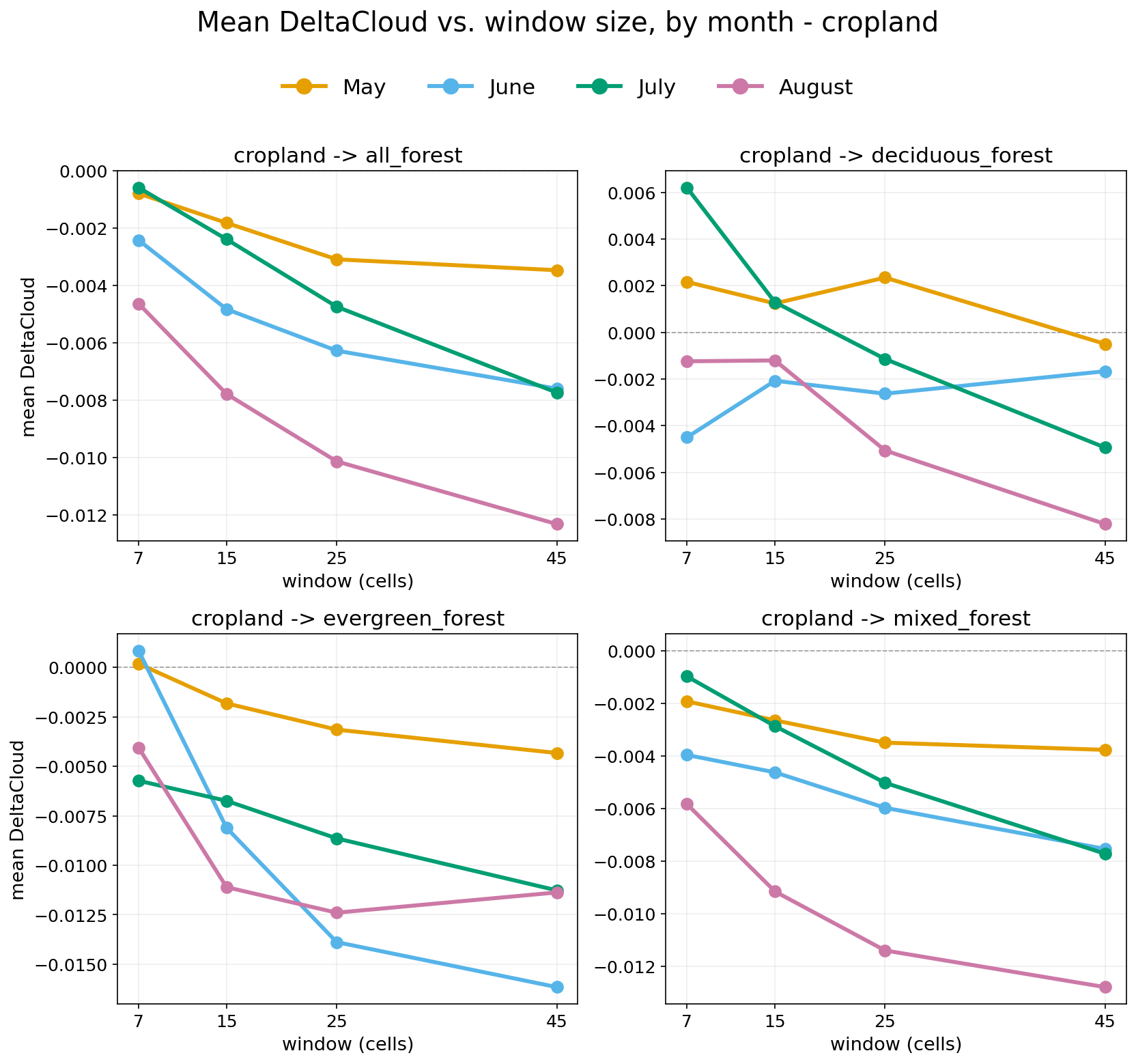
In Southern Germany, coupled-regime forest-cloud effects are contrasting rather than uniform: replacing cropland or low vegetation with different forest types shifts cloud fraction up in some configurations and down in others. Deciduous forest shows a small positive mean effect, while evergreen forest shows the strongest and most consistent negative association, varying further by season and spatial configuration.
Technology
The project uses Python-based geospatial analysis, visualization, statistical modelling and machine learning. It integrates satellite, climate, land-cover, canopy and terrain data to classify cloud–surface coupling, process observations at multiple resolutions, estimate local forest–cloud relationships and assess how vegetation structure, landscape configuration, terrain and weather influence cloud patterns.
Outlook
The project demonstrates the potential of combining satellite, climate and land-cover data to analyze vegetation–cloud interactions. Current research investigates how canopy structure and landscape characteristics influence local variations in these relationships while separating vegetation effects from terrain and meteorology. Future work will test the approach across European climate regions and integrate biodiversity observations to model ecosystem responses to climate and land-use change.
Team
Lead

Janet Mumo Mutuku
Leipzig University
Faculty of Physics and Earth System Sciences

Team Members
Janet Mumo Mutuku
Leipzig University
Faculty of Physics and Earth System Sciences

Prof. Dr. Johannes Quaas
Leipzig University
Chair of Theoretical Meterology


Prof. Dr. Gerik Scheuermann
Leipzig University
Chair of Image and Signal Processing

Dr. Josefine Umlauft
Leipzig University
Partners




Dresden
ScaDS.AI Dresden/Leipzig
Bürogebäude Strehlener Straße
Strehlener Straße 12, 14
01069 Dresden
Zentrum für Informationsdienste und Hochleistungsrechnen
ScaDS.AI Dresden/Leipzig
01062 Dresden
Leipzig
Löhrs Carré
Humboldtstraße 25, Uferstr. 11
04105 Leipzig
Data Science Center ScaDS.AI Leipzig
Internes Postfach: 322001
04081 Leipzig
Quicklinks:
Copyright 2026 © SCADS.AI Dresden/Leipzig – All rights reserved.