May 10, 2023
Data Science Challenge: 1st Place
Events
On March 7th 2023, four teams presented their results of the ScaDS.AI Data Science Challenge at the 20th Conference on Database Systems for Business, Technology and Web (BTW) in Dresden.
The challenge for the applicants was to choose a metropolitan area or a city with a sufficient density of sensors and other publicly available geodata for an analysis. The teams were tasked to find interesting facts and patterns in the data sources. On that basis, they were creating an analysis that answers a question of social relevance. Consequently, analyzing publicly available urban bicycle traffic data and other urban geographical data has advantages. For instance, it can help connect individual perspectives to analyze the big picture of urban bicycle infrastructure in future projects.
As a result, the participants presented or visualized their analysis in purely textual form. A jury of experts from research, cities and industry evaluated their projects and announced the placings on March 8th 2023:
- 1st place: Recommending Alternative Cycling Routes via Predicted Usage Patterns (Men, Dakai; Becktepe, Jannis; Esmailoghli, Mahdi; Bermbach, David; Abedjan, Ziawasch)
- 2nd place: Predicting Bike Traffic Using Graph Neural Networks: Integrating Residential Density, Amenity Distribution, and Street Networks (Chou, Wen-Chuang)
- Two 3rd places: Analyzing Cargo Bike Usage in Leipzig for Improved Bike-Sharing System (Petersen, Hauke; Plank, Martin) und In-Database Machine Learning on Bicycle Data from Munich (Großmann, Christoph)
The first three places were rewarded with a prize money from a pool of 1000 euros.
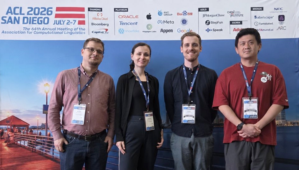
Winning team of the Data Science Challenge 2023
The following paragraph provides an abstract of the project “Recommending Alternative Cycling Routes via Predicted Usa” by Dakai Men, Jannis Becktepe, Mahdi Esmailoghli, David Bermbach and Ziawasch Abedjan:
How to find the best way through Berlin by bike? Although Google Maps is the most popular choice, it turns out it may not always lead the cyclist down the best path. Consequently, locals can recommend routes that a new-to-town traveler would never discover on their own and which can make a significant difference in the safety of bike riders.
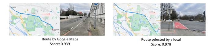
To discover safer and more suitable routes for cycling we leverage the data generated by many volunteers using tracking apps to log their bike riding behavior. We leverage usage data collected by the SimRa app in Berlin to understand which roads were taken by cyclists, including tracked statistics such as speed, location, and possible incidents during several bike rides. Furthermore, we combine the usage data with additional environmental data, such as weather and road information, and train a machine learning model to analyze the behavior of local users based on these environmental features.
Our machine learning model is ultimately trained to rank the possible routes between a given starting point and a destination based on their similarity to the potential locals.
As a result, a routing service specifically designed for cyclists is essential to ensure their safety, protect the environment, and provide local knowledge.
More about this analysis can be read here: Recommending-Alternative-Cycling-Routes-via-Predicted
The results of the teams were evaluated according to various criteria, such as Social relevance and Data visualization.
We thank all participants for their engagement and interesting projects!
funded by:

ScaDS.AI Dresden/Leipzig (Center for Scalable Data Analytics and Artificial Intelligence) is a center for Data Science, Artificial Intelligence and Big Data with locations in Dresden and Leipzig.
Dresden
Visitor address
Technische Universität Dresden
ScaDS.AI Dresden/Leipzig
Bürogebäude Strehlener Straße
Strehlener Straße 12, 14
01069 Dresden
ScaDS.AI Dresden/Leipzig
Bürogebäude Strehlener Straße
Strehlener Straße 12, 14
01069 Dresden
Postal address
Technische Universität Dresden
Zentrum für Informationsdienste und Hochleistungsrechnen
ScaDS.AI Dresden/Leipzig
01062 Dresden
Zentrum für Informationsdienste und Hochleistungsrechnen
ScaDS.AI Dresden/Leipzig
01062 Dresden
Leipzig
Visitor address
ScaDS.AI Dresden/Leipzig
Löhrs Carré
Humboldtstraße 25, Uferstr. 11
04105 Leipzig
Löhrs Carré
Humboldtstraße 25, Uferstr. 11
04105 Leipzig
Postal address
Universität Leipzig
Data Science Center ScaDS.AI Leipzig
Internes Postfach: 322001
04081 Leipzig
Data Science Center ScaDS.AI Leipzig
Internes Postfach: 322001
04081 Leipzig
Quicklinks:
Copyright 2026 © SCADS.AI Dresden/Leipzig – All rights reserved.