July 30, 2025
The Secret Network of Extreme Floods
Research
Our understanding of flood risk has traditionally centered on single causes – be it intense rainfall, rapid snowmelt, or saturated soils. The recent study by Jiang, S., Tarasova, L., Yu, G., & Zscheischler, J. “Compounding effects in flood drivers challenge estimates of extreme river floods” published in the Science Advances (Vol. 10, Issue 13, 2024), exposes a more intricate reality: extreme river floods often emerge from nonlinear interactions among multiple drivers. It therefore represents the first global, event‐level quantification of compounding flood drivers, combining advanced explainable machine learning with hydrological analysis across thousands of catchments.
Utilizing an explainable machine-learning pipleline, Jiang et al. not only unravel the hidden web of rainfall–soil–snow–temperature interplays but also introduce the “flood complexity” metric – a robust indicator of how driver interactions vary with flood magnitude. Published in a top‐tier, peer‐reviewed journal, the study sets a new benchmark for interdisciplinary flood science, offering both methodological breakthroughs and actionable insights for risk management. Furthermore, in over half of the 3.527 catchments analyzed worldwide, these compounding effects amplify flood peaks beyond what any individual factor could produce. Marking how compounding flood effects are not rare anomalies but rather ubiquitous features in many river basins.
Methodological Framework
Jiang et al. harnessed LightGBM for discharge prediction and Shapley Additive Explanations (SHAP) to decompose model outputs into main effects and pairwise interactions. By training on daily discharge peaks (1981–2020) alongside seven-day precipitation, mean temperature, antecedent soil moisture, and snowpack inputs, they quantified each driver’s contribution – and, thus crucially how pairs of drivers compound to worsen flood severity.
Interactive Drivers of Flood Magnitude
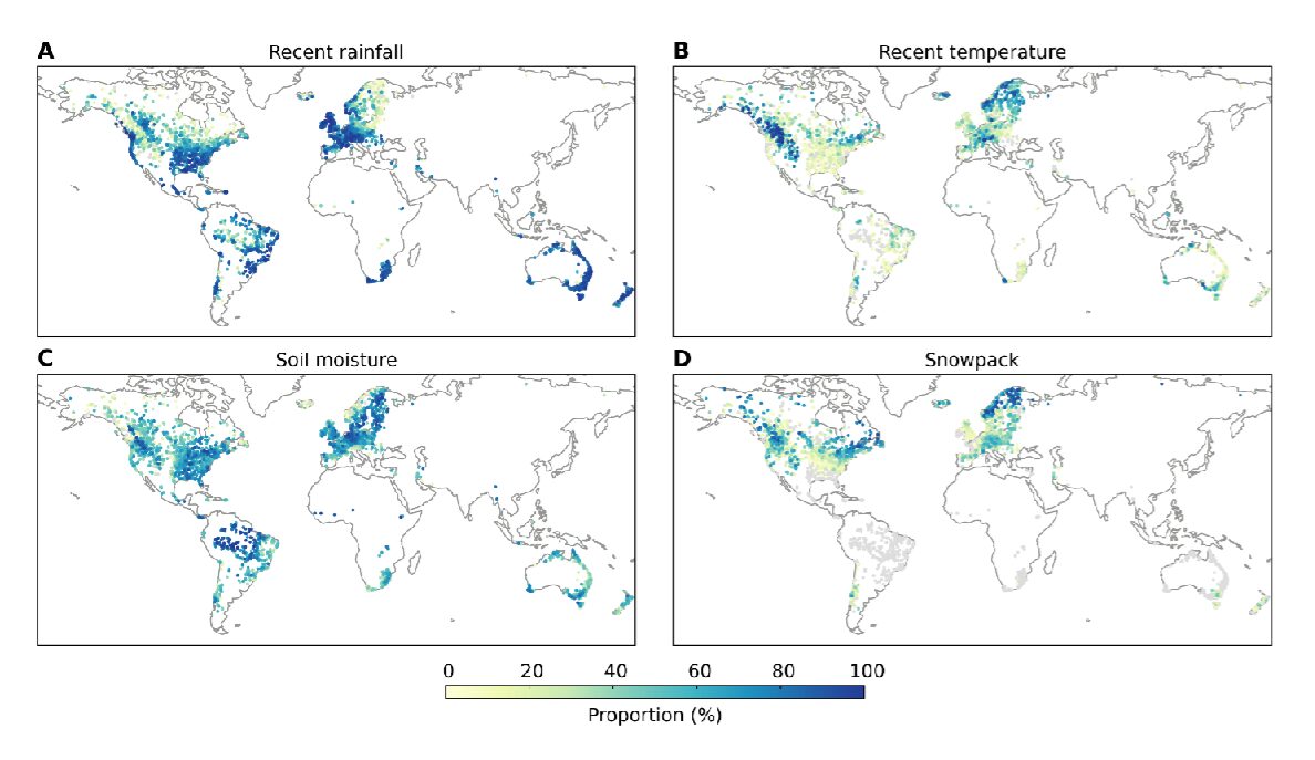
Four primary variables underpin flood generation:
- Recent Rainfall: Direct precipitation input over the catchment’s surface.
- Antecedent Soil Moisture: Stored water affecting infiltration and runoff.
- Snowpack: Seasonal accumulation dictating the volume available for melt.
- Air Temperature: Controls phase changes and snowmelt rates.
SHAP interaction values reveal that when any two of these factors jointly exceed critical thresholds, peak discharges can be 20 – 50 % higher than single-driver events. The most prevalent coupling is heavy rainfall with elevated soil moisture, a pairing that pre-conditions the basin to respond explosively to subsequent rainfall events.
Case Study: Central European Catchment
Consider a mid-latitude river basin in central Europe. A moderate spring shower alone – return period ~2 years – might pose minimal flood risk if soil moisture remains low. Yet, if that same precipitation follows a warm spell that has partially melted residual snowpack, SHAP analysis identifies a strong soil moisture–snow interaction. The resulting flood magnitude exceeds the expected discharge by roughly 30 %, illustrating how compounding drivers convert ordinary rain into an extreme event.
Limitations of Traditional Models
Flood-frequency methods commonly assume homogeneity in flood-generating processes and often fit distributions to annual maxima without regard for underlying driver complexity. Jiang et al. demonstrate that in catchments with high “flood complexity,” such approaches underestimate the true magnitude of the largest floods by an average of 17 %. Overall, this systematic bias poses tangible risks for levee design, insurance underwriting, and urban planning.
Applications and Future Directions
This work was made possible because of ScaDS.AI‘s collaborative infrastructure – uniting hydrologists, data scientists and high-performance computing experts across Dresden and Leipzig. It exemplifes our mission to translate innovative AI techniques into actionable insights for climate resilience.
By elucidating the secret network of flood drivers, ScaDS.AI researchers are pioneering tools, which could support the development of practical tools to mitigate flood risks such as:
- Interactive SHAP Dashboards: Enable practitioners to explore driver contributions for specific catchments in real time.
- Flood Complexity Mapping: Identifies regions where multivariate interactions dominate, guiding investment in monitoring infrastructure.
- Dynamic Early-Warning Systems: Integrate soil moisture and snowpack observations with precipitation forecasts to better predict compounding flood peaks.
Looking ahead, extending this framework to future climate scenarios – where snowmelt regimes shift and precipitation extremes intensify – will be critical to create more robust flood projections. Incorporating the knowledge on flood complexity into risk management planning will help rendering communities better prepare for extreme floods.
Acknowledgments
This research would not have been achievable without the collaboration and support of multiple institutions. We extend our sincere thanks to the Helmholtz Centre for Environmental Research – UFZ, the Max Planck Institute for Biogeochemistry, and the ELLIS Unit Jena, which contributed expertise in hydrology, climate science, and AI methodology. We also thank the TUD Dresden University of Technology and Leipzig University for providing computational infrastructure, interdisciplinary collaboration, and scientific leadership. Special recognition goes to the HPC Cluster EVE, jointly operated by UFZ and the German Centre for Integrative Biodiversity Research (iDiv), for enabling large-scale data processing. The study also benefited from international partnerships with the Desert Research Institute (USA) and support from funding initiatives including Helmholtz COMPOUNDX, the Carl Zeiss Foundation, and the EU Horizon 2020 program (XAIDA). Their contributions reflect the power of integrated environmental intelligence in tackling climate-driven challenges.


funded by:

ScaDS.AI Dresden/Leipzig (Center for Scalable Data Analytics and Artificial Intelligence) is a center for Data Science, Artificial Intelligence and Big Data with locations in Dresden and Leipzig.
Dresden
Visitor address
Technische Universität Dresden
ScaDS.AI Dresden/Leipzig
Bürogebäude Strehlener Straße
Strehlener Straße 12, 14
01069 Dresden
ScaDS.AI Dresden/Leipzig
Bürogebäude Strehlener Straße
Strehlener Straße 12, 14
01069 Dresden
Postal address
Technische Universität Dresden
Zentrum für Informationsdienste und Hochleistungsrechnen
ScaDS.AI Dresden/Leipzig
01062 Dresden
Zentrum für Informationsdienste und Hochleistungsrechnen
ScaDS.AI Dresden/Leipzig
01062 Dresden
Leipzig
Visitor address
ScaDS.AI Dresden/Leipzig
Löhrs Carré
Humboldtstraße 25, Uferstr. 11
04105 Leipzig
Löhrs Carré
Humboldtstraße 25, Uferstr. 11
04105 Leipzig
Postal address
Universität Leipzig
Data Science Center ScaDS.AI Leipzig
Internes Postfach: 322001
04081 Leipzig
Data Science Center ScaDS.AI Leipzig
Internes Postfach: 322001
04081 Leipzig
Quicklinks:
Copyright 2026 © SCADS.AI Dresden/Leipzig – All rights reserved.