DiGuRal
Title: DiGuRaL-Project — Digital Design of the Leipzig Urban Space Project
Project duration: 2023 – 2026
Research Area: Smart City
As public road space is subject to rapid change, new challenges arise in terms of traffic and mobility transformation. A future-oriented solution requires, in particular, rapid adaptation of urban and traffic planning. Digitalization can help optimize planning processes and make them more efficient. For this to happen, the necessary database must be expanded and made more usable.
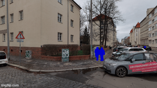
To implement this, city cleaning vehicles will be equipped with cameras and sensor technology such as LiDAR to ensure the quality of the road space. We are developing intelligent systems that will automatically evaluate the collected data. These assessments allow conclusions to be drawn about the condition of the road space. We are especially interested in objects that might change quickly over time or compromise the traffic flow.
Aims
The goal of DiGuRaL is to make data on stationary and moving traffic available to the Urban Data Platform (UDP) of the City of Leipzig, as well as to interested parties from industry and municipalities. For this purpose, existing and newly collected data will be combined, processed and harmonized. As a result, anonymized data sets will be used to promote a safe and efficient evaluation of road space and intelligent traffic management for the Leipzig urban area.
- The primary objective is to minimize the amount of time and effort required to assess the road space of the city and devise a prudent maintenance strategy.
- Improved planning and prioritization of regular road inspections
- Targeted inspections in the event of anomalies
- Initiation and control of further measures to eliminate defects.
- Data privacy protection for employees and citizens.
Practical example
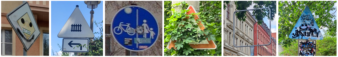
- Assess the quality and condition of the street surface, street signs, and street markings
- detect vegetation and find out where it overgrows the street and must be trimmed
- anonymize people and cars in the images

Technology
- Computer Vision models for Object Detection, Semantic Segmentation, and Image Classification
- LiDAR technology and 3D point cloud processing
- data protection and privacy techniques
Outlook
- computer vision algorithms can be used in almost any application field
- LiDAR technology is also used for autonomous driving and remote sensing
- the developed system could be used in different cities
- collect and compare data over a long period of time
- analyze developments
Team
Lead

Prof. Dr. Erhard Rahm
Leipzig University
Department of Computer Science, Database Group, Chair of Databases
Dr. Eric Peukert
Leipzig University
Department of Computer Science
Team Members

Miriam Louise Carnot
Leipzig University

Florens Rohde
Leipzig University
Partner
- Aufbauwerk Leipzig
- Stadt Leipzig
- Stadtreinigung Leipzig
- Universität Leipzig
- ccc Software GmbH
- Cyface GmbH

Dresden
ScaDS.AI Dresden/Leipzig
Bürogebäude Strehlener Straße
Strehlener Straße 12, 14
01069 Dresden
Zentrum für Informationsdienste und Hochleistungsrechnen
ScaDS.AI Dresden/Leipzig
01062 Dresden
Leipzig
Löhrs Carré
Humboldtstraße 25, Uferstr. 11
04105 Leipzig
Data Science Center ScaDS.AI Leipzig
Internes Postfach: 322001
04081 Leipzig
Quicklinks:
Copyright 2026 © SCADS.AI Dresden/Leipzig – All rights reserved.